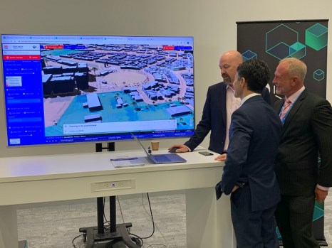
Bathurst has become the first major regional centre in NSW to be added to the Live NSW Spatial Digital Twin, with the city’s central business district captured in a 3D model.
It will now be part of a statewide digital grid, which will help in the planning for future infrastructure needs, such as schools, hospitals and roads.
“Council, planners and the local community will be able to use this to make more informed planning decisions, visualise buildings and ensure a development is sensitive to the surrounding environment — from the shadows a building is likely to create or changes to the traffic volumes before construction even begins,” said Deputy Premier and Minister for Regional NSW, Paul Toole.
The addition of Bathurst into the Spatial Digital Twin is the first step in a statewide rollout.
“People will be able to see the entire city in a 3D model and can view and explore existing infrastructure, including schools, hospital, parking and roads, as well as important future projects and their impact on the city, including shading, canopies and building heights,” added Minister for Customer Service and Digital Government, Victor Dominello.
“Plugging into the Digital Twin will help to future-proof planning because you can see it in the context of the current world and the future world.
“Seeing how infrastructure, data and building plans fit together in 3D will enable better, long-term planning of cities as NSW continues to evolve and expand.”
The NSW Spatial Digital Twin is being tested for faster approvals for development applications, which is expected to deliver $256 million in savings across 10 years.
*This story first appeared in Spatial Source.
Comment below to have your say on this story.
If you have a news story or tip-off, get in touch at editorial@governmentnews.com.au.
Sign up to the Government News newsletter