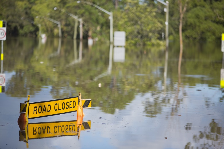
A risk study for the Hawkesbury Nepean Valley has painted a catastrophic worst-case flood scenario in which 90,000 people would have to be evacuated and 12,000 homes would be affected by floodwaters.
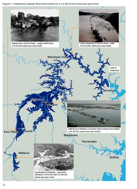
In the rare likelihood of the area being hit by a “maximum flood”, the city of Wallacia and large parts of Penrith would be inundated, Pitt Town would become an island and almost the entire Richmond/Windsor flood plain would be underwater.
The Hawkesbury Nepean Regional Floods Study released by Infrastructure NSW released this week is the first to be done in 20 years. It uses state-of the art modelling and new climate change calculations to forecast risk for the region under a range of flood likelihoods.
The report has been made available to councils to help with land use, emergency management and evacuation planning. It affects the Penrith, Hawkesbury, Blacktown and The Hills LGAs, as well as Wollondilly, Liverpool, Central Coast and Hornsby councils.
Releasing the plan this week Minister for Western Sydney Stuart Ayers said the information, covering the main flood plains of Wallacia, Penrith/Emu Plains and Richmond/Windsor, is a vital step in reducing flood risk for people living and working in the valley.
“The Hawkesbury-Nepean Valley has the highest flood exposure in NSW, if not Australia,” he said.
“Since the last regional flood studies were done over 20 years ago there have been significant improvements in the science of flood modelling, increased understanding about climate change, and changes within the valley.”
20,000 possible flood events
The new study modelled almost 20,000 possible flood events, representing what could be expected over 200,000 years.
An overview of the three-volume study says there have been no major floods in the area since 1992 but the valley has a long history of damaging flood events and there have been about 130 moderate to major floods since record keeping began in the 1790s.
The largest flood in living memory was in November 1961 when the water reached 14.5 metres above normal river height at Windsor.
The largest on record was in 1867 when waters reached 19 metres above normal at Windsor and flood waters reached Penrith’s city centre, inundating most of Emu Plains.
The report says if a similar flood occurred now, more than 90,000 people would need to be evacuated and 12,000 homes would be impacted by floodwater.
The study models for 11 different flood events, from highly likely floods – or floods that have a one in five chance of occurring in any given year- to extremely rare events with a one in 100,000 chance of occurring. At the end of the spectrum is the so-called Probable Maximum Flood (PMF).
The report says Wallacia has the potential for the deepest flooding in the valley, and a flood similar to the one in 1867 would cut all major evacuation routes. A PMF would completely inundate the village of Wallacia and large areas of Penrith.
McGrath’s Hill would become completely submerged in a one in 100 flood, while Pitt Town would “become a flood island, as would parts of Windsor and south Windsor”.
In an event similar to the 1867 flood, Windsor would be completely isolated. In a PMF very little land would remain above water in the Richmond/Windsor floodplain, according to the modelling.
The study says increases in global temperatures will lead to an increase in the intensity of rare rainfall and an increased flood risk and increased flood levels at Wallacia, Penrith, North Richmond and Windsor and Wiseman’s Ferry.
A spokesman for Penrith City Council said council was across the flood risk. “We are doing extensive flood risk work already,” he told Government News.
Comment below to have your say on this story.
If you have a news story or tip-off, get in touch at editorial@governmentnews.com.au.
Sign up to the Government News newsletter.
We are in the Sutherland shire and just received a letter from the Council telling us our property was”prone” to flooding when I followed this up incredulous that e were “prone” to flooding I found that in one of these once in 200,00 year events water would reach the front corner of our driveway.
Why are we designated ” prone” to flooding for such an infinitesimally unlikely event that would affect less than a square metre of our property? Sydney has an earthquake on a much more regular basis (at least every 50 years) yet no where in sydney would be considered Earthquake prone.
I am sure the Murray-Darling Basin would welcome flood spillway diversion from the Nepean through to the headwaters of the Lachlan. Send the floodwater our way, not a problem.
Clearly there’s a water issue for the west and inland areas. Flood water diversion as sated here by Gil Hardwick is an excellent idea. Water and the management of it seems to be a state government and federal government failure. A similar system like the Bradfield scheme of capturing flood waters and diverting it to areas that could use it seems to be worth the study. How the government can spend 50 billion on submarines built by the French seems absolutely ludicrous while a nation project to water Australia is ridiculed .
Does the scenario modelling include the simultaneous running of a king tide? In all my years working on the water issues of the Hawkesbury-Nepean, this was not done. The river is currently tidal up to Windsor … is the predicted sea level rise being taken into account?
Does your modelling include flood levels at Wallacia with Warragamba Dam Emergency spillway at full flow which could happen with a 1% AEP. With Wallacia designated as a Low Flood Island by Penrith Council will the water get to over 60m above sea level at Wallacia?
Just noticed the new Flood Evacuation Route sign that has been erected on Park Rd Wallacia . It directs the traffic straight through Jerry’s Creek which floods. I can’t see many cars making along that route after reading this article. Whoever decided on this route should have read the government’s report first.
So now it is really flooding ,The NSW Premier says its Bad.
But the Premier and her Ministers have allowed, to point of effective of Promoting more housing on the Floodplain to be built on.
Yet the Western Sydney Minister seems to be saying we need to build a higher wall in Warrangamba Dam.
Purpose : So Developers can fit more Houses and business on the floodplain?
Meanwhile, Insurance Companies are saying: Its a floodplain, so your not covered!
Is there something BASICALLY wrong with the plans that our Government has