A cutting-edge tool has been developed which uses Google maps to alert authorities of street signs that need replacement or repair.
The tool, developed by geospatial scientists, automates the process of detecting road infrastructure faults and issues, saving councils time and money.
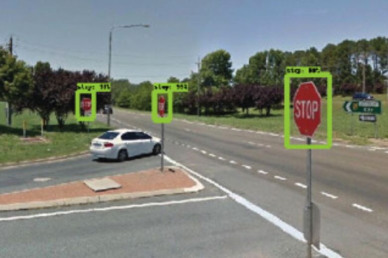
The tool, which is able to record the geolocation of signs from 2D images, is highly accurate, detecting signs with 96 per cent accuracy and identifying their type with 98 per cent accuracy.
Study lead author and RMIT University Geospatial Science Honours student, Andrew Campbell, said a trial model has been trained to see ‘stop’ and ‘give way’ signs, but could be trained to identify other infrastructure and was easily scalable for use by local governments and traffic authorities.
“Councils have requirements to monitor this infrastructure but currently no cheap or efficient way to do so,” Mr Campbell said.
“By using free and open source tools, we’ve now developed a fully automated system for doing that job, and doing it more accurately.”
The tool is substantially more accurate than the manual process, which uses GPS location data in existing street sign databases and can sometimes be as inaccurate as 10 metres off target, according to Mr Campbell.
“Tracking these signs manually by people who may not be trained geoscientists introduces human error into the database. Our system, once set up, can be used by any spatial analyst – you just tell the system which area you want to monitor and it looks after it for you,” he said.
RMIT geospatial scientist and project co-lead, Dr Chayn Sun, said the increasing use of cameras on rubbish trucks to help councils find street data showed the value of visual data to local authorities.
“This imagery is critical for local governments in monitoring and managing assets and with the huge amount of geospatial applications flourishing, this information will only become more valuable,” Sun said.
“Ours is one of several early applications for this to meet a specific industry need but a whole lot more will emerge in coming years.”
Other visual data such as that from rubbish trucks or the road network could be fed into the same system, according to Mr Sun.
“Where footage is already being gathered, our research can provide councils with an economical tool to drive insights and data from this existing resource,” she said.
Comment below to have your say on this story.
If you have a news story or tip-off, get in touch at editorial@governmentnews.com.au.
Sign up to the Government News newsletter.