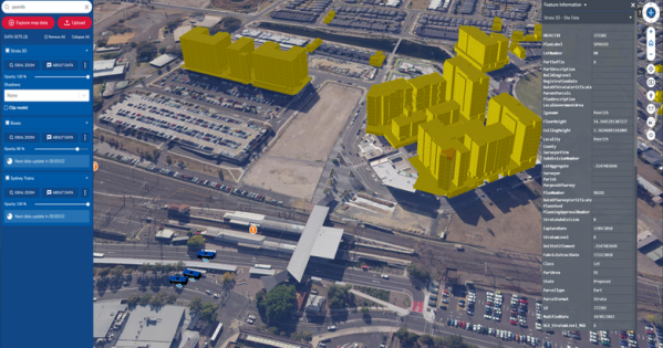
Govt programs recognised for innovative use of GIS technology
Australian government agencies are using geospatial information technology to modernise services and operations.
13 July, 2023
Australian government agencies are using geospatial information technology to modernise services and operations.
13 July, 2023
Linking information to location.
10 April, 2017
Australasia’s biggest annual spatial event.
4 April, 2017
Establishing baseline data for Canberra’s urban tree canopy.
31 March, 2017
Data counts. So do people.
7 April, 2016
Booming spatial industry urgently needs young talent to avert a skills shortage
28 January, 2016
Data driven fleet intelligence.
19 November, 2015
Australia is preparing to usher in a leap second to correct official clocks.
29 June, 2015
This survey sponsored by …
7 May, 2015
Using mapping for disaster planning.
7 May, 2015
NSW Finance Minister Perrottet bites back.
4 May, 2015
How technology can combat crime.
23 January, 2015
Resources handbook scoops GIS gong.
2 October, 2014
GIS to track government assets.
24 September, 2014End of content
No more pages to load
Garth Daddy on: War memorial contracts fudged, audit finds
Roger Buhlert on: New VLGA appointment vows to lift governance standards
Roger Buhlert on: APS hybrid work is here to stay, report finds